


몽블랑의..."100년간 치명적 기후변화" VIDEO: Aerial photographs reveal 100 years of ice loss on Mont Blanc after scientists recreate images taken by a Swiss pilot in 1919


Aerial photographs reveal 100 years of ice loss on Mont Blanc after scientists recreate images taken by a Swiss pilot in 1919

Coordinates of the original photo were worked out and scientists flew there in a helicopter to take photos
They took the same pictures, showing the white ice covered less ground as it recedes in rising temperatures
One warned that climate change means a photo in 2119 could show no ice at all if climate change isn't stopped
By SAM BLANCHARD FOR MAILONLINE
PUBLISHED: 10:47 BST, 11 October 2019 | UPDATED: 01:04 BST, 12 October 2019
몽블랑의..."100년간 치명적 기후변화"
1919년 스위스 조종사의 사진과의 비교 항공사진은 알프스 산맥에서 가장 높은 산인 몽블랑이 지난 100년 동안 얼마나 많은 것을 잃었는지를 보여주었다. 1919년에 찍은 사진 한 장이 올해 정확히 재현되었다. 산의 정상을 보여주고, 치명적인 기후 변화가 강조되고 있다.. 하얀 얼음 덩어리가 눈에 띄게 줄어들었고 지금은 불모지로 보인다. 복수의 GPS 장치를 이용해 정확한 위치를 찾아내고 카메라로 헬기를 매달고 있던 한 과학자가 8월 촬영해 이번 주에 공개했다. 그리고 이미지 뒤에 있는 팀은 기후 변화를 늦추기 위한 조치가 취해지지 않는 한, 2119년의 사진은 거의 얼음이 보이지 않을 수도 있다고 말했다. 던디대 연구진은 1919년(왼쪽) 스위스 조종사 월터 미텔홀저가 촬영한 정확한 위치를 파악한 뒤 헬기(오른쪽)에서 사진을 찍어 빙하가 얼마나 사라졌는지 알아챘다 Dundee 대학의 Kieran Baxter 박사는 말했다: '우리가 고도에 도달했을 때 얼음 손실의 척도는 명백했지만, 그것은 단지 지난 100년간의 변화를 나란히 비교함으로써 나타난 것이다. '그것은 숨막히는 동시에 가슴아픈 경험이었으며, 특히 지난 수십 년 동안 용해 속도가 엄청나게 빨라졌다는 것을 알고 있었다. via video 황기철 콘페이퍼 에디터 큐레이터 Ki Chul Hwang, conpaper editor, curator |

edited by kcontents
Aerial photographs have revealed how much ice Mont Blanc, the highest mountain in the Alps, has lost in the past 100 years.
A photograph taken in 1919 has been exactly recreated this year showing the top of the mountain and highlighting the toll climate change has taken on it.

Dr Kieran Baxter took a helicopter flight to take the photo. He said he worried there would be even less ice next time someone attempts the comparison, as global warming continues to melt the glaciers
Patches of white ice have visibly shrunk and now appear as barren land.
A scientist using multiple GPS devices to find the exact spot and hanging out of a helicopter with his camera took the shot in August and revealed it this week.
And the team behind the image said that, unless action is taken to slow down climate change, 2119's photograph might show almost no ice at all.
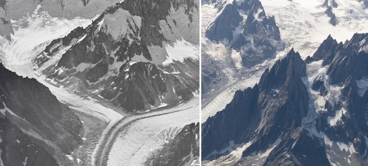
Researchers from the University of Dundee took a photo from a helicopter (right) after working out the exact location of one taken by Swiss pilot Walter Mittelholzer in 1919 (left) and noticed how much glacier ice had disappeared

Researchers say a section of the Planpincieux glacier, in the Italian Alps is at risk of sliding off the mountain and into the Ferret valley below, sparking evacuations
Dr Kieran Baxter, from the University of Dundee, said: 'The scale of the ice loss was immediately evident as we reached altitude but it was only by comparing the images side-by-side that the last 100 years of change were made visible.
'It was both a breathtaking and heartbreaking experience, particularly knowing that the melt has accelerated massively in the last few decades.'
His photograph recreates – from the exact same coordinates – one taken by Swizz pilot and photographer Walter Mittelholzer from a biplane a century ago.
Although that one was in black and white, the difference is plain to see.
Dr Baxter and his colleague Dr Alice Watterson used computer maps and the layouts of the mountains to work out where Mittelholzer took his photograph from.

Walter Mittelholzer, a pilot and photographer from Switzerland, took his own picture from a biplane 100 years ago
Then they took a helicopter to revisit the site and recreate the photo themselves.
The resulting photograph shows glaciers named Argentiere, Mont Blanc Bossons and Mer de Glace.
And the change in the shading on their surfaces shows how much ice has been lost since the end of the First World War.
Dr Baxter added: 'Mittelholzer played a key role in popularising commercial air travel in Switzerland, an industry which ironically came to contribute to the warming of the climate and the detriment of the alpine landscapes that the pioneering pilot knew and loved.

Dr Kieran Baxter (pictured) said: 'The scale of the ice loss was immediately evident as we reached altitude but it was only by comparing the images side-by-side that the last 100 years of change were made visible'
View full text
VIDEO;
kcontents
